Nobel Resources Corp. Reports Induced Polarization (IP) Survey Results and Drilling Update, Algarrobo Copper-Gold Project, Chile
August 16, 2021
TORONTO, Aug. 16, 2021 (GLOBE NEWSWIRE) -- Nobel Resources Corp. (TSX-V: NBLC) (the “Company” or “Nobel”) has completed induced polarization (“IP”) surveys over the key mineralized areas and associated magnetic features identified by previously released magnetic surveys (news release June 11, 2021) on its Algarrobo copper project in Chile (Figure 1) (the “Project” or the “Algarrobo Project”). The Company has also received assays for the initial wide spaced drill program.
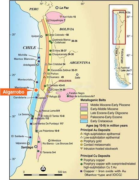
Figure 1: Location of the Algarrobo copper project, Chile.

The objective of the program has been to identify targets for drilling that have the scale to host a potential major copper deposit. The Project area has been subject to artisanal mining for decades which demonstrates the presence of high grade copper mineralization extending over at least 5 kilometers of strike length in numerous mineralized structures exposed in mine openings in the northeast part of the Project area (the Northeast Trend) (Figure 2). The Company has also identified a second mineralized trend (the Gloria Trend) in the southern part of the property (Figure 2). The Project is unusual in that there is limited basic geological mapping or documentation of the geological controls on the mineralization given the long history of mine development. To accomplish this objective, the following has been completed:
- Coverage of the entire Project property by high resolution ground magnetometer survey (see news release June 11, 2021).
- Coverage of key areas with IP surveys to detect mineralization within priority magnetic features and associated mineralized structures. This survey responds to sulphide minerals at depth that would be oxide mineralization nearer to surface (typically in the top 120 meters in this area).
- Complete a wide spaced drill program, coupled with geological mapping and trenching to provide the geological base required to properly interpret the geophysical surveys.
David Gower, P.Geo., CEO of Nobel noted: “The work to date is generating very interesting geophysical anomalies with large scale, in areas with known copper mineralization or along the projection of major mineralized trends. It is unusual in my experience to be doing the basic geological and geophysical surveys in an area with so much evidence of extensive copper mineralization, and located within the Chilean copper belt, one of the most prolific copper producing areas in the world.”
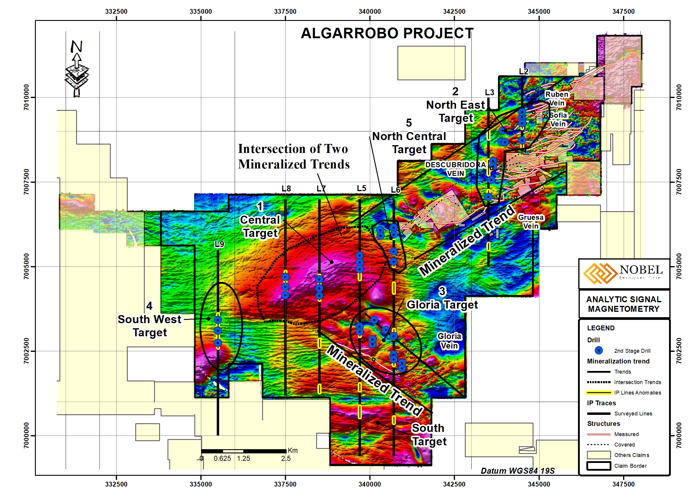
Figure 2: Property map showing IP anomalies and coincident magnetic anomalies. Particularly note the large Central Target in an unexplored area at the intersection of two copper mineralized structural trends.

The geophysical surveys have identified high priority targets where large scale magnetic features are directly coincident with IP anomalies comprising chargeability highs and resistivity lows which is the correct response for a mineralized system with large scale potential. Key target areas have been identified (Figure 2) as follows:
- The Central Target occurs in an area of the Project that is completely dune covered and has never been explored. The magnetic anomaly is directly coincident with an IP anomaly comprising a chargeability high and resistivity low and occurs precisely in the area where two mineralized structural trends appear to intersect. The coincident magnetic / IP anomaly is approximately 4 km X 1.5 km in this target area. It appears that the target is controlled along a contact between an unmineralized intrusive unit and a mineralized granitic unit with a very definite break in the anomaly along that contact which is a geological setting shared by other IOCG deposits including Marimaca and Michilla.
- The Northeast (NE) Target (Figure 2) has one of the stronger IP responses and occurs closest to the area with the highest concentration of historical mine workings. This anomaly extends at least 2.5 km in a northeasterly direction and is approximately 750 meters wide.
- The Gloria Target (Figure 2) is a coincident IP / magnetic anomaly within the Gloria Trend in an area that has not been tested previously. There are high grade copper oxide veins in trenches at surface adjacent to the anomaly. The feature extends approximately 2 km in a northwesterly direction towards the Central Target and is approximately 500 meters wide.
- The South Target is a coincident magnetic and IP target south of the Gloria Trend (Figure 2). Geological mapping is pending for this area. There is a magnetic anomaly on the south end of Line 9 (Figure 2) (data pending) that appears to be along the NE Trend that is yet to be surveyed. There is a powerline crossing this magnetic feature so it may not be feasible to do IP there.
According to Vernon Arseneau, P.Geo., COO of the Company: “The results of the geophysical surveys have provided targets that are very compelling. This Project is extensively mineralized with copper mineralization in structures that have been mined for over a century, and artisanal workings that extend for over 5 kilometers. The Central Target is a priority given its scale and the structural setting at the apparent intersection of two mineralized structural trends. We will complete the surveying, including certain areas in the Central and NE targets for detailed IP follow up in the coming week to better position drill holes and promptly complete the interpretation and data integration to lay out the next phase of diamond drilling which is expected to commence in September. The Central and Northeast Targets will be the first areas drilled.”
Details of the Induced Polarization Survey
The responses from the Company’s IP survey are in line with known low-iron type IOCG mineralized systems such as Michilla in Antofagasta, where the presence of sulphide minerals, comprise mainly, digenite and bornite, and to a lesser extent covellite and chalcopyrite. Other example of low-pyrite systems in Chile are Marimaca and its satellite prospects, Cyndy and Mercedes, located 5km and 3km respectively to the north of Antofagasta. The Ivan Mine is another example with directly related chargeability despite of its low content of pyrite.
The survey was completed by Argali Geofisica EIRL, a highly experienced geophysical contractor in the Chilean copper environments. Approximately 30 line-kilometers of IP surveying was originally laid out but the Company has expanded the survey to 45 km in order to follow-up on significant anomalies that were identified as the survey progressed.
IP Survey Details
The pole dipole array with dipoles of 100m and 200m has been utilized to obtain deep penetration of 400m or more, along lines up to 8 km in length. Most of the lines traverse large expanses of sand dunes where data acquisition has long been expected to be difficult, and no IP surveys have been conducted previously despite potential for mineralization. Sand dunes (mostly in the central and western parts of the grid) were expected to present problems for the pole-dipole array which requires many regularly spaced current electrodes along the line. With recent rainfall in the desert however, the ground conditions for transmitting current into the ground improved significantly which allowed for effective surveying, resulting in good chargeability data being acquired in the sand dune cover. The pole-dipole survey has targeted mainly and covered the large semi-circular magnetic anomaly with line spacing of one kilometer or more (Central Target). Follow-up, infill lines at closer spacing are planned once the recently acquired data has been fully interpreted. A total of seven lines of IP have been surveyed to date for some 40 km of coverage.
Line 337500E (Line 8) shows a chargeability up to 16 mV/V which is the strongest anomaly seen other than the eastern lines. The IP anomaly is exactly coincident with a deep-rooted conductive zone, similar to the Descubridora anomalies. The anomaly is deeper and in a more conductive environment near the surface, likely due to water in the overlying alluvial cover and weathered material.
Line 340700E (Line 6) shows that there is moderately strong chargeability anomaly near 7003000N, coincident with a strong magnetic anomaly and immediately east of the chargeability anomaly on 339700E (which in turn is about 500m N of Gloria). There are pronounced magnetic anomalies under sand cover in the vicinity of this chargeability anomaly including an elongated magnetic high trending NW. In addition, two parallel NE-trending structures are noted, with one passing through the anomaly on 339700E and the other through 340700E. There are several weaker chargeability anomalies along the line also, correlating with magnetic features.
Another chargeable zone with amplitudes from 15 to 19 mV/V is located on the north end of the two eastern lines. This chargeable zone is about 500 m wide, it could be a single feature or could be a manifestation of numerous closely spaced narrowed anomalies at depth. Sulphide mineralization is expected at depths of 100 to 300m. The Northeast anomaly appears to weaken at depth, suggesting that there may be a certain horizon favorable for sulphide mineralization. Some conductive anomalies are located within and flanking the chargeable zone, but high resistivities appear to underlie the chargeable horizon. Multiple veins and workings are present on the surface in the area adjacent to these anomalies, so abundant copper is present. This anomaly represents a strong target, particularly the stronger anomaly on Line 344500E.
Diamond Drilling Results
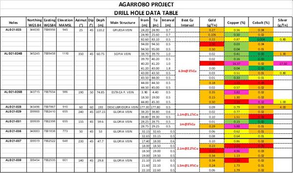
The Company completed 31 diamond drill holes, for which assays results for 12 drill holes on wide spaced areas within the Algarrobo Project were previously released (June 11, 2021) and the remaining results are included below. The holes were designed to provide geological information and test mineralized areas identified by artisanal miners over approximately a 12 kilometer area and have been valuable in providing geological and structural information for the ongoing program. The drilling has indicated that the oxide veins are quite erratically mineralized and high grade zones occur within plunging structures that pinch and swell both along strike and at depth. The drilling was conducted early in the program and focused on areas with known artisanal workings. This type of small-scale target is not a focus for the Company. Table 1 below has a list of the drill holes with locations and hole orientations and Figure 3 shows drill hole locations. The best results from the last part of the drill campaign were:
Figure 3: Location of the 31 diamond drill holes from the initial program. Please refer to news release dated June 11, 2021 for results of the earlier reported holes included on this map.

Program Summary
Copper mineralization has been intersected at shallow depths on various mineralized structures extending over approximately 12 km across the Project (Figure 2). Intervals for which the Company has assays generally range from 1.5 to 3.5 meters thick. To date drilling has targeted previously known mineralized structures and work has not been directed towards the larger scale deposit model pending completion of the magnetic and IP surveys. Mineralized intercepts for which assays have been received are listed below. A detailed table with locations is included at the end of the release. Drill core is logged in the Company core facility and descriptions entered into a data base. See below for a detailed description of the sampling procedure.
Sampling Protocol
Sampling is conducted in a manner that will allow reasonable averaging and statistical analysis of the data for resource estimation. Standards, blanks and duplicate samples, are used to maintain quality control and to verify laboratory procedures.
- Samples were collected using a standard 0.5m to 1m sample length in the main mineralized zones and a 1m to 2m length in the surrounding rocks or in other minor intervals of alteration and/or mineralization. Shorter sample lengths were avoided whenever was possible.
- Core samples were split along the core axis using an electric rock saw, by the Company’s trained technicians, prior to sampling the core is logged and a high-resolution photographic record was taken for the files.
- One standard sample was inserted for each 20 core samples and one coarse blank, one fine blank and one internal duplicate sample were included each 50 core samples for QA/QC control.
- In order to meet NI 43-101 security standards, the samples were placed in rice bags and sealed with numbered security tags on site and then shipped to the laboratory facilities by truck by Company personnel. The custody and transfer of samples was always the responsibility of Company personnel.
Laboratory Analysis
All analyses of the samples were carried out by ALS Limited, an independent laboratory with all regulatory documents and certifications approved and up to date. The sample prep facilities are based in Copiapo, 90 km far from the project.
The analysis package chosen, for Au, Cu and Co, and a multielements, trace level method are as follows:
| ALS CODE |
Lower Limit
detection |
Upper limit
detection |
Description
|
INSTRUMENT |
| Au-AA23: |
0.005 ppm |
10 ppm |
Fire Assay |
Atomic Absorption Spectroscopy |
| Cu-AA62 |
0.001% |
40% |
Four Acid |
Atomic Absorption Spectroscopy |
| Co-AA62 |
0.001% |
20% |
Four Acid |
Atomic Absorption Spectroscopy |
| ME-ICP61 |
|
|
Four Acid |
Atomic Emission Spectroscopy |
Drill Hole Data Table 1

FOR FURTHER INFORMATION PLEASE CONTACT:
David Gower
Nobel Resources Corp.
Email: info@nobel-resources.com
Qualified Person
The scientific and technical information in this news release has been reviewed and approved by Mr. Vernon Arseneau, P.Geo, and Mr. David Gower P.Geo., Qualified Persons as defined by National Instrument 43-101 of the Canadian Securities Administrators.
Cautionary Note Regarding Forward-looking Information
This press release contains “forward-looking information” within the meaning of applicable Canadian securities legislation. Forward-looking information includes, without limitation, statements regarding the mineralization of the Project, the prospectivity of the Project, the Company’s exploration program and the results thereof, the Company’s drill program and the Company’s future plans. Generally, forward-looking information can be identified by the use of forward-looking terminology such as “plans”, “expects” or “does not expect”, “is expected”, “budget”, “scheduled”, “estimates”, “forecasts”, “intends”, “anticipates” or “does not anticipate”, or “believes”, or variations of such words and phrases or state that certain actions, events or results “may”, “could”, “would”, “might” or “will be taken”, “occur” or “be achieved”. Forward- looking information is subject to known and unknown risks, uncertainties and other factors that may cause the actual results, level of activity, performance or achievements of Nobel29, as the case may be, to be materially different from those expressed or implied by such forward-looking information, including but not limited to: general business, economic, competitive, geopolitical and social uncertainties; the actual results of current exploration activities; risks associated with operation in foreign jurisdictions; ability to successfully integrate the purchased properties; foreign operations risks; and other risks inherent in the mining industry. Although Nobel29 has attempted to identify important factors that could cause actual results to differ materially from those contained in forward-looking information, there may be other factors that cause results not to be as anticipated, estimated or intended. There can be no assurance that such information will prove to be accurate, as actual results and future events could differ materially from those anticipated in such statements. Accordingly, readers should not place undue reliance on forward-looking information. Nobel29 does not undertake to update any forward-looking information, except in accordance with applicable securities laws.


